01.ap-GEOGRAPHY
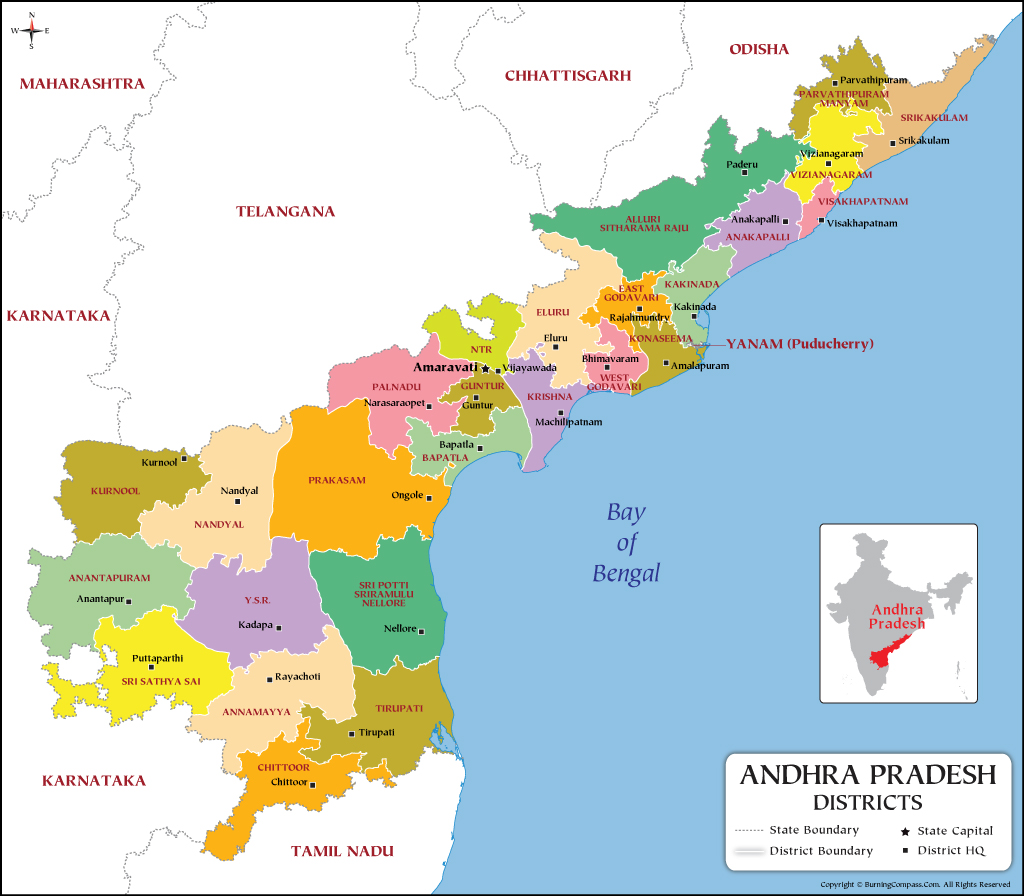
time line of andhra pradesh
?
%%{ init: { 'theme': 'base', 'themeVariables': { 'primaryColor': '#EFEFEF', 'fontSize': '25px', 'primaryTextColor': '#0f766e', 'primaryBorderColor': '#7C0000', 'lineColor': '#F8B229', 'secondaryColor': '#006100', 'tertiaryColor': '#fff' } } }%%

flowchart TD
	a{At the time of Independce} --- b[Andhra Pradesh part of Madras]
	a-->c{1953} --- d[Coastal Andhra and Rayalaseema seperated from madras]
	--- h{{By Wanchoo committee}}
	--- f[Oct 1st 1953]
	 --- e[Andhra Pradesh formed]
	 ---  g[Kurnool as Capital]
	 --- i[First Linguistic state as per the 1956 state reogranisation act]
	 --- j[13 districts = 9 coastal 4 Rayalaseema]
	c --> k{1956}
	--- l[Debhar Committee]
    --- m[Nov 1st 1956 ]
    --- n[Merging AP + Hyderabad]
    --- o[Andhra Pradesh Formed]
    k --> p{1960}
     --- q{{Pataskar Commission}}
     --- r[Large part of Tiruttani Taluka of T.N were Added to A.p]
     p --> s{1969}
      --- t[Agitation]
      s--> u{1970}
      --- v[Prakasam new district from Guntur Distirct,Nellore and Kurnool]
      u --> w{1972}
      --- x[Agitation]
      w-->y{1979}
      --- z[Vijayanagaram From visakhapatnam and srikakulam]
      --- 1[13 districts now]
      y-->2{2000}
      ---3[agitation]
      2--> 4{2nd june 2014}
      --- 5[Telangana]
      4--- 6[Andhra]
      6 --- 7[13 districts]
      --- 9[670 mandals]
      --- 10[50 revenue divisions]
      5--- 11[got 10 disticts from Andhra]
      4-->12{2022}
      12---13[jan 26]
      ---14[proposed 13 new districts]
      --- 15[under section 3 of 5]
      12 --- 16[april 4th]
      --- 17[New districts were formed]
      17--- 18[26 districts]
      ----19[670 to 679 mandals]
      ---20[76 revenue divisions]
      18---21[Rayalaseema -8 districts]
18---22[Coastal - 18 districts] - The total number of districts in the country - {{727}}
- The state having highest number of districts in the country - {{Uttar Pradesh-75}} whereas the state having least number of districts in the country - {{Goa}}.
- The average population of in each districts in the Andhra pradesh - {{19.7}}.
- The law dealing with the powers of the state - AP distirct formation ACT, 1974
- The AP government had issued the official gazette notification for carving 13 new districts under the AP districts formation act 1974, section 3(5), on january 25, 2022.
- The final gazette regarding to new district was released by the government - april 03, 2022.
- The date newly formed districts came into force April 04, 2022.
- Total number of districts at present in the state - 26 (8 from rayalaseema + 18 from coastal Andhra).
- Total number of revenue divisions in Andhra Pradesh - {{76cue-tr taxes give revenue}}.
- Total number of Mandals - {{679}}.
state symbols
official language :: telugu
flower :: jasmine
emblem :: amaravati shcool of art , dharma chakra wheel of law triratnas.
2011 census how many districts, population and %of population:: 26 districts, 4.9 crore, 29.6% urban area.
population division :: 58.32 and 41.68
drougth :: 3rd largest drought prone area.
ports :: vishakapatnam and muthukur.
butter fly theme park :: kondapalli reserve.
sports :: kabadi
animal :: black buck
dance :: kuchipudi
tree :: neem margosa
.
bird :: rose ringed parmeet -- parrot.
Official song {{Ma telugu thalliki Mallepu dhanda}} declared as offcial song in {{1975}}
state official acquatic animal {{Dolphin}}
state official news channel {{sapthagiri on sep 17 20144i}}
physical features
- Andhra Pradesh State is situated in South east of India and extends between {{
}} North latitudes {{ }} east cue-INHI IPOT-In Nepal Hukka Increased Indian Police Ordered Tracing -longitudes with the {{lock key shape}}.
- Amaravathi called as {{The peoples capital}}
- Andhra Pradesh is called as {{sun rise state}}
Capital
- {{Amaravathi}} (The People's Capital) was declared as it's capital on {{23}}rd {{April}}, {{2015}} with the brand name of "Sun Rise State".
- The foundation stone was laid on {{22 October 2015, }}at Uddandar ayunipalem village in Thulluru Mandal by the Prime Minister, Narendra Modi. The metropolitan area of Guntur and Vijayawada are the major conurbations of Amaravati.
-
Amaravati is the de facto capital city of the Indian state of Andhra Pradesh.
-
The planned city is located on the southern banks of the {{Krishna}} river in Guntur district, within the Andra Pradesh Capital Region, being built on a {{217}} sq km river front designed to have 51% of green spaces and 10% of water bodies. The word "Amaravati" derives from the historical Amaravathi Temple (Now it is in Palnadu district) town, the ancient capital of the Satavahana dynasty.
- On December 30, 2014 CRDA (Capital region development authority) in Vijayawada was setup for the development of Capital city of Amaravathi.The total extent of the CRDA is 8,603.32 sq.km, within these the core capital extent is 217.23 sq.km. C.M acted as Chairman of CRDA.
- Andhra pradesh area position in India {{7th}}.
Geographical extent :
- It's area is {{1,62,970}} sq.km, consisting {{4.87}}% in the total extent of the India and occupies {{8 changed to 7 after the JK bifurcation}}" position based on area in the country. (Source:AP economic survey 2023)cue-7-T-tirumala
- Note: But After the Bifurcation of J&K in 2 UT's AP stands {{7}}th position as per geographical area in the country)cue-7-T-tirumala.
Largest Districts by Area (sq km)
?
- P - prakasam
- A - Alluri sitaramaraj
- Y - Ysr
- Phonepe- pottisriramulu
- Prakasam District (14,432)
- Alluri Sitaramaraj (12,251)
- YSR (11,228)
- Potti Sriramulu Nellore (10,441)
Smallest Districts by Area (sq km)
?
- Violence - vishakapatnam
- Against - Ambedkar
- women- west godavari
- girls - guntur
- Visakhapatnam District (1,048)
- Dr.B.R. AmbedkarKonaseema (2,083)
- West Godavari District (2,178)
- Guntur District (2,443)
Population
- As per 2011 census total population of the state is {{4.95}} crores (4.09%), occupies {{10}}" position in the total population of the country. Within these {{70.53}}% is rural population and {{29.47}}% is urban population.
Largest districts in terms of population (in lakhs)
?
- potti - potti sriramulu nellore
- prakash - prakasam
- king - kurnool
- acting - ananthapur
- Potti Sriramulu Nellore (24,697)
- Prakasham (22.88)
- Kurnool (22.71)
- Ananthapur (22.41)
Smallest districts in terms of population (in lakhs)
?
- parvathi - parvathipuram
- alluri - alluri sitaramaraj
- banging - bapatla
- ambedkar - Dr.Br.Ambedkar (konaseema)
- Parvathipuram Manyam (9.253)
- Alluri Sitaramaraj (9.53)
- Bapatla (15.86)
- Dr. Br.Ambedkar (17.19)
- Mandals: At present total number of Mandals in the state {{679}}cue-679-RTP -Roja Terminated from Party.
Districts with highest mandals
?
- Potti - sri potti sriramulu nellore
- Prakash - prakasam
- Yesterday - YSR
- Terminated - Tirupati
- Prakasam District & SriPotti Sriramulu Nellore (38)
- YSR (36)
- Tirupati (34)
Districts with least mandals
?
- visakha - visakhapatnam
- parvathi - parvathipuram
- Visakhapatnam District (11)
- Parvathipuram Manyam (15)
Population Density :
- As per 2011 census total population of the density is {{304}}, where as it is {{382}} in the country.cue-304-moh-manushulu operating in House, 382-mbn-manushulu bathukuthunaru in national
Highest density populated districts
?
- very - visakhapatnam
- good - guntur
- Visakhapatnam District (1870)
- Guntur (856)
Least density populated districts
?
- andhra - alluri sitaramaraj
- pradesh - prakasam
- Alluri Sitaramaraj District (78)
- Prakasam (160)
- Population Growth rate : As per the 2011 census population growth rate of the state is {{9.21}} as against the {{17.70}} of the national average.
- Sex ratio: As per the 2011 census it is {{997}}, cue- 997 ppr - 9 times a day sex is not good because 9 months delivery reduces to 7 months. where as it is {{983}} in 2001 census. (The national average is 943).
- Literacy rate: As per the 2011 census it is{{ 67.35}}%, cue reading time (rt) 3 to 5 As against the national average of {{72.98}}**cue-7+2=9, before 9 is 8%
- Urbanisation: Urbanisation has been regarded as an important component for growth realization. The percentage of urban population to the total population in the state is {{29.47}} percent in 2011 as compared to 24.13 percent in 2001.
- Total urbanised districts in AP, As per 2011- {{Vishaka patnam}} district
- Total rural districts in AP, As per 2011 - {{Alluri seetharama raju}} district
Number of Tribal districts in the state (2)
?
- Andhra - Alluri seethramaraju
- Pradesh - parvathi puram manyam
- Alluri seethramaraju,
- Parvathi puram manyam.
- The district having highest number of Assembly constituencies in AP- {{Potti sriramulu (8)}}
- The district having lowest number of Assembly constituencies in AP-{{Alluri seetharama raju (3)}}
- Total number of coastal districts in AP 12. which are given below
?
- Srikakulam
- Vijayanagaram
- Vishaka
- Anakapalli
- Kakinada
- Dr.B.R.Ambedkar
- West godavari
- Krishna
- Bapatla
- Prakasam
- Nellore
- Tirupathi
- The district having longest length of coastline in AP - {{Srikakulam}}
- The district having least length of coastline in AP - {{West Godavari}}cue west is having good production in shrimp and it supports pawan kalyan so jagan gave least sea land
- Total number of land locked districts in AP (3)
?
- youth - ysr
- entertainment - east godavari
- group - guntur
- YSR
- East godavari
- Guntur
- The districts in the state having border with highest number of other districts
?
- youth - ysr
- entertainment - east godavari
- group - guntur
- YSR (6)
- East godavari (5)
- Guntur (4)
The districts in AP having border with neighbouring states
State
Border districts
1.Odisha (3)
?
- Srikakulam,
- Parvathipuram manyam,
- Alluri seetharama raju
2. Chattisgarh (1)
?
- Alluri seetharama raju
3. Telangana(7)
?
PN PN KEA
- Alluri seetharama raju,
- Eluru,
- NTR,
- Palnadu,
- Prakasam,
- Nandyala,
- Kurnool.
4. Karnataka (5)
?
- Kurnool,
- Ananthapuram,
- Sri satyasai,
- Annamaiah,
- Chittoor
5.Tamilnadu (2)
?
- Chittoor,
- Thirupathi
The districts in AP recognised with famous personalities from the state :
?
- Prakasam - 1972 (It was formed in 1970, February 2nd)
- Sri potti sriramulu - 2008
- YSR Kadapa - 2010
- Sri satyasai - 2022
- Annamaiah - 2022
- Alluri - 2022
- Dr. B.R. Ambedkar - 2022
- NIR - 2022
- Balaji - 2022
- Above districts {{srikakulam}} has longest coast line where as {{West Godavari}} has least length of coast line.cue srikakulam have no money so jagan gave large sea ⛵ land to earn profit
%%{ init: { 'theme': 'base', 'themeVariables': { 'primaryColor': '#EFEFEF', 'fontSize': '25px', 'primaryTextColor': '#0f766e', 'primaryBorderColor': '#7C0000', 'lineColor': '#F8B229', 'secondaryColor': '#006100', 'tertiaryColor': '#fff' } } }%%

flowchart TD
 a[As per A.P Reorganization Act 2014]
 a-->d[ on 17th July, 2014]
 d--- e[TELANGANA]
 e---i[ Bhadradri district]
 i--- f[7 polavaram flooding Mandals, 327 villages]
 d--- c[ were transfered to residual Andhrapradesh state]
 f--- H[4 were merged in East godavari]
f--- j[ 3 were merged in West godavari ]Merged mandals East Godavari
?
- Chinturu(present ASR)
- Kunavaram (present ASR)
- Vara Rama Chandra Puram
- Bhadrachalam (Partially Merged)Regional division of the A.P
- cue chinna kukka ramudini Bhadrak ga chusukuntundhi
Merged mandals in West Godavari
?
- Velairpadu (Present Eluru)
- Kukunoor (present Eluru)
- Burgampadu
Regional division of the AP
- Navyandhra pradesh has been divided into 2 geographical regions, such as
? - #Rayalaseema Region
- #Coastal Andhra region
Rayalaseema Region :
- It has the total area of {{67,291}} km. It is well known region for droughts and economically most backward region. It consist of total {{8}} districts at present.
rayalaseema table
No.
Districts
Area
Population
Revenue
(Sq.km)
2011 census
Divisions
Ananthapuram
Sri Satyasai
Kurnool
Nandyala
YSR Kadapa
10,205
2241105
03
8,925
1840043
04
7,980
2271686
03
9.682
1781777
03
11,228
2060654
04
Revenue
Mandals
81
32
26
29
36
A.P Location & Physical Setting
A.D.V. Ramana Raju
Annamayya
Chittoor
7,954
6,855
1697308
1872951
03
04
Tirupathi
8.231
2196984
04
30
31
34
- The district having largest area in Rayalaseema region - {{YSR Kadapa.}}
- The district having largest population in Rayalaseema region - {{Kurnool}}cue-easy it has muslims so obviously populated
- The district having smallest area in Rayalaseema region - {{Chittoor}}.
- The district having smallest population in Rayalaseema region - {{Annammya}}
- The district having largest number of mandals in Rayalaseema region - {{YSR Kadapa}} and Distirct having least mandals in Rayalaseema region - {{Kurnool}}.
- The only Rayalaseema district having coastline - {{Thirupathi}}
Coastal Andhra region:
- Coastal region has the total area of {{95,470 sq.km}}
- It has the total area of {{95,470}} sq.km and drained by Godavari, Krishna & Penna rivers. Comparatively well developed region. than the Rayalaseema region. It consist of {{11}} districts which are located along with the Bay of Bengal coast line and remaining {{7}} other districts which are away from the Bay of Bengal together called as Coastal Andhra region.
coastal table
Area (Sq.km)
Srikakulam
Vijayanagaram
Vishakapatnam
Anakapaili
Kakinada
Dr. B.R.Ambedkar
East Godavari
West Godavari
Eluru
Krishna
NTR
Guntur
Bapatla
4,591
4.122
1,048
4,292
3,019
2,083
2,561
2,178
6,679
3,775
3,316
2,443
3,729
Population
Revenue Revenue
2011 census Divisions Mandals
2191437
03
30
1930811
27
1959544
11
1726998
24
2092374
21
1719093
22
1832332
19
1779935
19
2071647
28
1735079
25
2218591
20
2091075
18
1586918
25
Location & Physical Setting14.15.16.
Palnadu
Prakasham
SPS Nellore
7,298
140322
10,441
2041729
2288026
2469712
A.D.V. Ramana Raju
28
38
38
Tribal districts
Parvathipuram
3.659
Alluri sectharama raju 12,251
925340
953960
2
15
22
coastal data Note
- The district having largest area in Coastal Andhra region - {{Prakasam}}
- The district having largest Population in Coastal Andhra region - {{SPSNellore}}
- The district having lowest area in Coastal Andhra region - {{Vishaka}}
- The district having lowest populated in Coastal Andhra region - {{Parvathi puram manyam}}
- The district in Coastal Andhra region having largest number of mandals
?
- Prakasam followed by
- PottiSriramulu
- The district having lowest mandals - {{Vishaka }}
Emblem of Andhra Pradesh
- creator
- three thing about the emblem
- name written in how many languages
- armiger
- crest
- torse
- blazon
- motto
?
- Creator of State Emblem
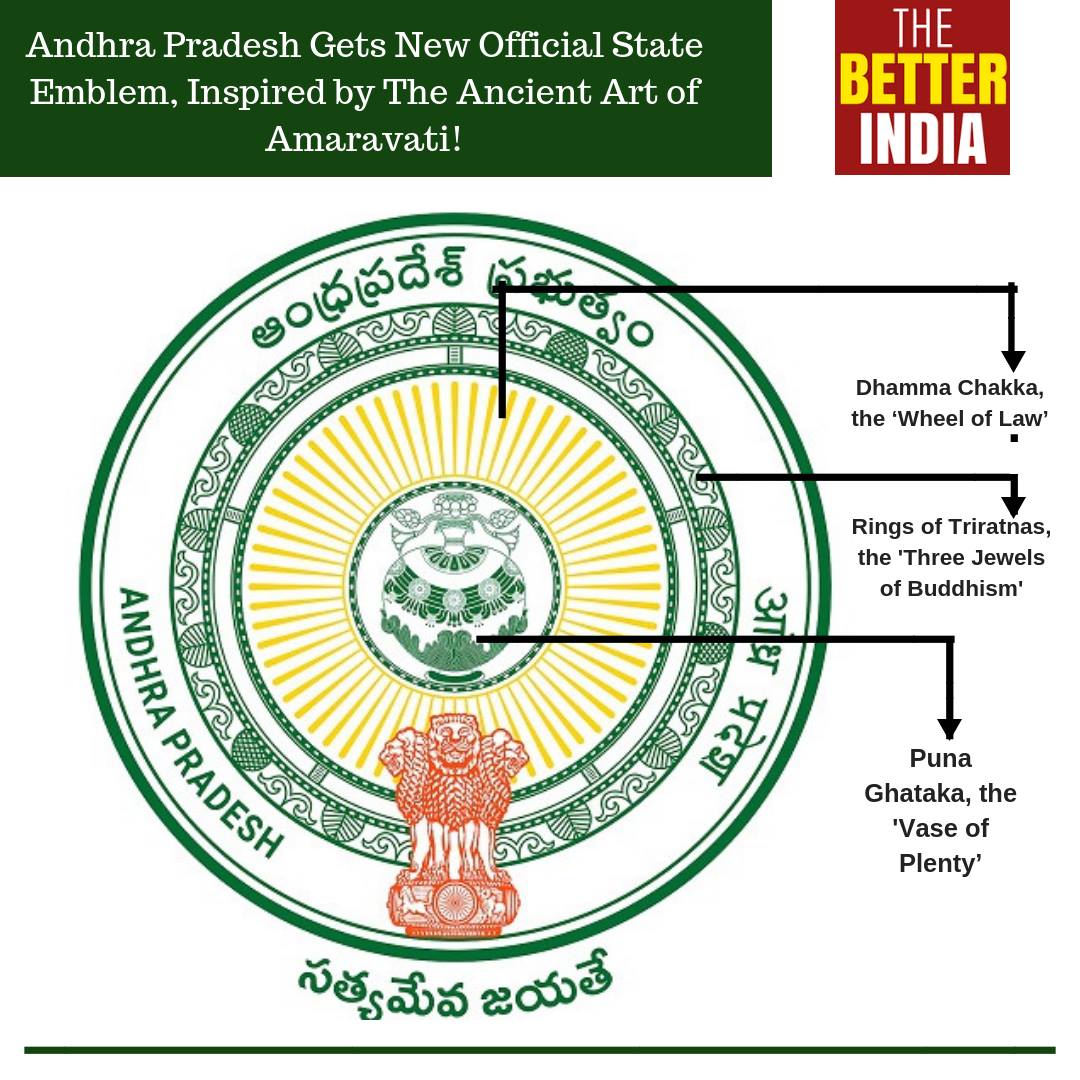
• Soorisetty Anjineyulu, a drawing master from Nellore is the creator of the emblem, which was selected out of 300 emblems that were submitted. - Symbol of Andhra Pradesh
- The emblem features are,
- Purna Ghataka at the centre encircled
- Dharmachakra symbolising the "wheel of law", portrayed from Amaravati school of arts,
- Surrounded by the name of the state in Telugu, English and Hindi
- The emblem features are,
- Armiger
- The Government of Andhra Pradesh
- Crest
- The National Emblem of India
- Torse
- Dharma chakra
- Blazon
- Purna Ghataka, Dharmachakra
- Motto
- Satyameva Jayate, Sanskrit for "Truth Alone Triumphs
- Ap formation day was observed as {{November 1st from 2019}} on wards.